Continental Shelf Research
A considerable amount of academic research has been generated from data acquired by the UK for its Article 76 claims. In particular focus has been on the Hatton-Rockall margin where work has been concentrating on the margin break-up dynamics and also on the sedimentary processes active on the margin and foot of slope region.
These works have been published in peer-reviewed journals - and include:
Elliott, G. and Parson, L.M. (2008) Influence of sediment drift accumulation on the passage fop gravity driven sediment flows in the Iceland Basin, NE Atlantic. Marine and Petroleum Geology, 25, (3), 219-233.
MacLachlan, S.E., Elliott, G.M. and Parson, L.M. (2008) Investigations of the bottom current sculpted margin of Hatton Bank, NE Atlantic. Marine Geology, 253, (3-4), 170-184.
Elliott, Gavin M. and Parson, Lindsay M. (2008) Influence of margin segmentation upon the break-up of the Hatton Bank rifted margin, NE Atlantic. Tectonophysics, 457, (3-4), 161-176.
 Elliott, G. and Parson, L.M. (2008)
Influence of sediment drift accumulation on the passage fop gravity driven sediment flows in the Iceland Basin, NE Atlantic.
Marine and Petroleum Geology, 25, (3), 219-233.
(doi:10.1016/j.marpetgeo.2007.07.002)
ABSTRACT
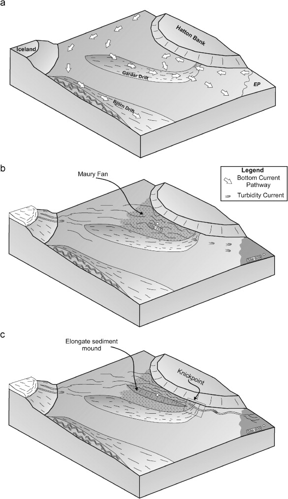
The Maury Channel is a deep-sea sediment transport system located in the Iceland Basin and extends from the Icelandic plateau southwards towards the Charlie-Gibbs Fracture Zone (CGFZ). This study has utilised multibeam bathymetry and multi-channel seismic reflection survey data along 480 km of its 1200 km pathway. In the northern reach of the channel it is predominantly broad (>20 km) and shallow (not, vert, similar10 m). Further to the south the channel narrows (5-10 km) and locally deepens to 150 m prior to finally discharging onto the Eriador Plain to the north of the CGFZ. DSDP Site 115 in the Iceland Basin can provide insight into the evolution of the system as it sampled a suite of volcaniclastic turbidites of unequivocal Icelandic provenance. This sequence produces distinct amplitude anomalies on seismic reflection profiles allowing it to be mapped over an area of at least 26,000 km2. The southern edge of the high velocity unit is delimited by onlap onto the flanks of the Miocene (and younger) Gardar Drift. The drift appears to have initially acted as a barrier to southerly flows and promoted ponding of flows in the Maury Fan. Continued sediment supply from Iceland eventually filled the Maury Fan leading to the overspilling of the Gardar Drift dam. A result was the initiation of the Maury Channel. To the south of the drift, where the seabed is steep, flows are confined to the channel, whereas to the north of the drift, where the gradient is less, unconfined flow pathways dominate. The Maury Channel system highlights the interaction between turbidity currents and bottom currents on abyssal plains. The growth of sediment drifts not only mould the seafloor through their bathymetric development but also, through the building of seafloor topography, influence the passage and behaviour of gravity-driven sediment-laden flows along the seafloor.
Fig. 9. a) Evolution and rapid growth in the Iceland Basin of the Gardar and Bjorn Drifts occurred in the Miocene to produce large elongate sediment drifts following the onset of deep-water overflow over Greenland-Scotland ridge. (b) Onset of widespread Iceland glaciation brings icesheets to, or close to, the shelf-slope break allowing jokulhlaup derived turbidity current flows to move down the steep flanks of the Icelandic Plateau. These flows follow the broad southerly gradient towards the Hatton Bank, which deflects the flows to the southeast where they encounter the Gardar Drift. The Gardar Drift prevents further passage, promoting large-scale deposition of the coarse material with the potential of flow stripping occurring, allowing fine-grained deposition further to the south. (c) Continued sediment supply from Iceland and ponding behind the Gardar Drift, reduced the relative height of the barrier allowing overspill of the complete flows. The overspilling of the flows onto the steeper seabed, increased flow efficiency and incision of the Maury Channel occurred. The repeated flows promoted the incision and erosion of the Gardar Drift, in order to set up an equilibrium slope for the turbidity currents.
MacLachlan, S.E., Elliott, G.M. and Parson, L.M. (2008)
Investigations of the bottom current sculpted margin of Hatton Bank, NE Atlantic.
Marine Geology, 253, (3-4), 170-184.
(doi:10.1016/j.margeo.2008.05.012)
ABSTRACT
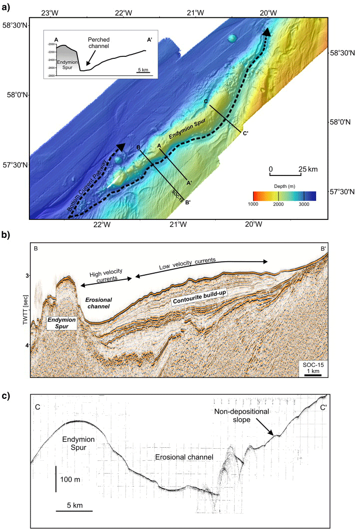
The northwest Hatton Bank margin is an ideal locality to demonstrate the interaction between bottom currents and slope configuration in controlling the distribution and morphology of bottom current deposits. The slope area investigated is isolated from any major terrigenous sediment supply and at present is influenced by the Deep Northern Boundary Current (DNBC). Swath bathymetry and high resolution acoustic data allow us to evaluate both local and regional controls on slope sedimentation and the possible mechanisms for bottom-current velocity variability across a slope setting within the NW European continental margin. The slope exhibits sculpting by bottom currents that flow in a predominantly southwest to northeast direction, and is only locally modified by slope failures. Positive relief features such as the Endymion Spur play an important role in constraining and accelerating bottom-current flow and, consequently, in redistributing sediment along the margin. We demonstrate that the size, morphology and distribution of bottom-current deposits along the slope vary as a function of the interaction between bottom currents, regional slope orientation and local seafloor topography.
Fig. 6. a) Hill-shade bathymetric map obtained with EM12 Multibeam system, showing the bottom current pathways around the Endymion Spur; b) SOC-15 multi-channel seismic profile across the southern part of the study area highlighting the bottom current pathway through the erosional channel; c) 3.5 kHz profile across the southern part of the study area illustrating the morphology of the erosional channel.
Elliott, Gavin M. and Parson, Lindsay M. (2008)
Influence of margin segmentation upon the break-up of the Hatton Bank rifted margin, NE Atlantic.
Tectonophysics, 457, (3-4), 161-176.
(doi:10.1016/j.tecto.2008.06.008)
ABSTRACT
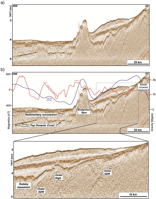
The Hatton Bank margin, flanking the Iceland Basin, is an example of a volcanic rifted margin and has been studied to examine the along margin tectono-magmatic variability. Integration of 5660 km of new seismic reflection profiles with > 60,000 km2 of new multibeam bathymetry has allowed the margin to be divided into three segments, each of which are flanked by oceanic crust. The southernmost segment is characterised by a series of inner and outer seaward dipping reflector (SDR) packages, which are separated by an "Outer High" feature. The outer SDRs are truncated by Endymion Spur, a chain of steep sided, volcanic cones connected by narrow septa or necks. The central segment has no Inner SDR package and is characterised by the presence of a continental block, the Hatton Bank Block (HBB). The northern segment is adjacent to Lousy Bank, with a wider region of SDRs recognised than to the south, and characterised by many volcanic cones. The variations in the distribution of the SDRs along the margin, the presence of the HBB and Endymion Spur all suggest that the break-up process was not a uniform smooth process along-strike. Structural segmentation controlled the variations along the margin with break-up initiated in the south, producing the SDR packages. The HBB prompted the focus of break-up to relocate outboard of the block. The northern segment was closest to the Iceland "hot-spot", and regular seafloor spreading did not become established until Chron 21. Shortly after break-up, the eruption of Endymion Spur occurred and may have been triggered by the passage of a pulse of hot asthenospheric material along the margin. The margin segmentation pattern we describe controlled the location of the enhanced volcanism along the Endymion Spur to the southern sector. In addition the segmentation has influenced the break-up style (presence or absence of SDR) and also the location and nature of post break-up volcanism.
Fig. 5. a) Uninterpreted section of seismic profile SOC-15 from southern sector of the Hatton Bank margin crossing Endymion Spur. b) Interpreted section of SOC-15 showing both inner and outer SDR packages separated an outer high feature. Total field magnetics and free air gravity are also shown.
Publications, Presentations & Posters
Members of the Marine Geoscience Group (UNCLOS) have presented their work to a wide audience, in the form of publications, lectures and posters. These works are listed below.
Publications
Sauter, D., Mendel, V., Parson, L.M., Fujimoto, H., Mevel, C. and Tamaki, K. 2005. Focused magmatism versus amagmatic spreading along the Southwest Indian Ridge. Evidence from TOBI sidescan sonar imagery. In press -Â Geochemistry, Geophysics, Geosystems.18pp, plus figures.
Miles, P.R., Pettit, R., Saunders, M.R. and Evans, A. 2004. Archive and re-use of Geophysical Records - A 21st Century Solution. Presentation to the South African Council for Geoscience, June 2004.
Parson, L.M. and Evans, A.J. 2004. Seafloor Topography and Tectonic Elements Of The Western Indian Ocean. Philosophical Transactions of the Royal Society (Series A: Mathematical, Physical and Engineering Sciences)
New, A, L. Stansfield, K. Smythe-Wright, D. Smeed, D, A. Evans, A.J. and Alderson, S.G. 2004. Physical and Biological Aspects of the Flow Across the Mascarene Plateau in the Indian Ocean. Philosophical Transactions of the Royal Society (Series A: Mathematical, Physical and Engineering Sciences)
Evans, A.J., Carleton, C. and Parson, L.M. 2003. The Ridge issue. ABLOS 2003 - Addressing Difficult Issues in UNCLOS. Conference papers. IHB, Monaco.
Mendel, V., Sauter, D., Rommevaux-Jestin, C., Patriat, P., Lefebrvre, F. and Parson, L.M. 2003. Magmato-tectonic cyclicity at the Ultra-slow spreading Southwest Indian Ridge: Evidence from Variations of axial volcanic ridge morphology and abyssal hills pattern. Geochemistry, Geophysics, Geosystems 4(5), 9102.
doi:10.1029/2002GC000417
German, C.R. Connelly, D.P. Evans, A.J. and Parson, L.M. 2002. Hydrothermal activity on the southern Mid-Atlantic Ridge. EOS: Transactions American Geophysical Union; 83(47). Supplement: AGU Fall Meeting 2002 Abstracts; p.F1420.
Van Dover, C.L., German, C.R., Speer, K.G., Parson, L.M., Vrijenhoek, R.C. 2002. Evolution and biogeography of deep-sea vent and seep invertebrates.. Science ; 295(5558); 1253-1257.
doi:10.1126/science.1067361
Sauter, D., Parson, L.M., Mendel, V., Rommevaux-Jestin, C., Gomez, O., Briais, A., Mevel, C. and Tamaki, K. 2002. TOBI sidescan sonar imagery of the very slow spreading Southwest Indian Ridge: evidence for along-axis magma distribution. Earth Planet. Sci Lett., 199, 81-95.
doi:10.1016/S0012-821X(02)00543-5
Evans, A.J. 2001. Generation of a new bathymetric chart of the Mascarene Ridge. Shoals of Capricorn Filed Report 1998 - 2001 - Marine science, training and education in the western Indian Ocean. Royal Geographical Society (with the institute of British Geographers), pp3-4.
Murton, B.J., Parson, L.M., Hunter, P. and Miles, P.R. 2001. Global Non-Living Resources on the Extended Continental Shelf: Prospects at the year 2000. Proceedings of the meeting on "Non-living marine resources beyond 200 nautical miles", International Seabed Authority Technical Report No. 1. 65pp, 40 Tables, 25 Figures
Parson, L.M., Gracia, E., Coller, D., German, C. and Needhan, D. 2000. Second order segmentation - the relationship between volcanism and tectonism at the MAR, 38 N - 35 40'N. Earth Planet Sci Lett. 178 . 231-251
doi:10.1016/S0012-821X(00)00090-X
Briais, A., Sloan, H., Parson, L.M. and Murton, B.J. 2000. Accretionary processes in the axial valley of the Mid-Atlantic Ridge 27 N - 30 N from TOBI side-scan images. Marine Geophysical Researches, 21, 87-119.
doi:10.1023/A:1004722213652
Carleton, C., Shipman, S., Monahan, D. and Parson, L. 2000. The practical realisation of the Continental Shelf Limit. In: Cook, P. and Carleton, C. (Eds) Continental Shelf Limits - The Scientific and Legal Interface. Oxford Press. Pp 268-281
German, C. and Parson, L.M. 1998. Distributions of hydrothermal activity along the Mid-Atlantic Ridge: interplay of magmatic and tectonic controls. Earth Planet Sci Lett.160, 327-341
doi:10.1016/S0012-821X(98)00093-4
German, C.R., Baker, E., Mevel, C., Tamaki, K., Blondel, Ph., Evans, A., Flewellyn, C, Matthew, D., Parson, L.M., Wallace, R., Boulanger, D., Sauter, D., Fujimoto, H., Osada, Y., Tamura, C., Yama-ashi, T., Gomez, O., Lee, S-M., Searle, R.C., Patriat, P., Pouliquen, G., Rommevaux-Justin, C., Yamada, T. 1998. Hydrothermal activity along the southwest Indian Ridge. Nature v. 395, p 490-493
doi:10.1038/26730
Parson, L.M., Sauter, D., Mendel, V., Patriat, P and Searle, R. 1997. Evolution of the axial geometry of the Southwest Indian Ocean Ridge between the Melville Fracture Zone and the Indian Ocean Triple Junction - Implications for Segmentation on very slow-spreading ridges. Mar. geophys. Res. 19. 535-552
doi:10.1023/A:1004335919592
German, C.R., Parson, L.M., Murton, B.J., and Needham, H.D. 1996. Segmentation and hydrothermal activity at the Mid-Atlantic Ridge - The tale of two hot-spots. In (MacLeod et al) Geol Soc Special Volume 118. pp 169-184.
Presentations
Invited presentation at Malaysia's Continental Shelf Workshop - Putrajaya, 2007
UK's joint submission in the Celtic Sea area - UN, New York, 2006/2007
Invited presentation at Africa Upstream 2006 conference - London, 2006.
Invited presentation at the International Symposium on Scientific and Technical Aspects of the Outer Limits of the Continental Shelf beyond 200 Nautical Miles (MFA, Japan and UN University, March 2006). Title:"Support for developing states - ideas to support countries with problems". Tokyo, Japan.
Invited presentation at meeting of technical experts on Article 76 of UNCLOS (Japanese Hydrographic Office, Tokyo, March, 2006). Title: :"Developing the desk-top study for developing countries".
Invited speaker at"Symposium on Problems of the Outer Continental Shelf" - International Tribunal for the Law of the Sea, Hamburg, Germany (September 2005). Title:"The Commission for the Limits on the Outer limits of the Continental Shelf - How is it working?"
Invited speaker at the Jackson School of Geosciences Symposium on UNCLOS - University of Texas, Austin, USA (October 2005). Title:"Article 76 of the United Nations Convention on the Law of the Sea".
Invited speaker at the 27th International Geological Congress, Florence (August 2005). Title:"Article 76 of UNCLOS: Prime driver for significant continental margin research, or a data black hole?"
Invited tutorial presentation on"Delimitation of the juridical continental shelf" At ABLOS Conference (October 2005): Marine Scientific Research and the Law of the Sea: the Balance between Coastal State and International Rights.
Invited presentation at Africa Upstream 2005 conference (November 2005). Title: "Africa's Deepwater EEZ Hydrocarbon potential, and Claims beyond 200 miles under UNCLOS", Cape Town, South Africa.
Co-convenor of Special Session at the American Geophysical Union Conference"UNCLOS and Continental Margins: Geodynamic constraints and implications for the legal continental shelf" (December 2005). Presentation title:"Continental Margins and the Law of the Sea - an 'Arranged Marriage' with Huge Research Potential. San Francisco, USA
Invited tutor at the UNEP/GRID Arendal training workshop on"Determining outer limits of the continental shelf for West Africa states". ( Nairobi, Kenya. March 2006)
'Continent-Ocean Transition research in the context of UNCLOS continental shelf delimitation" Geo-political aspects of continental margins' Special Session on Article 76 at the 32nd International Geological Congress, 20-28th August 2004, Florence, Italy.
ISA workshop for the establishment of environmental baselines at deep seafloor cobalt-rich crusts and deep seabed polymetallic sulphide mine sites in the Area, for the purpose of evaluating the likely effect of exploration and exploitation on the marine environment. 6-10 September 2004, ISA, Kingston, Jamaica.
"Addressing Difficult Issues in UNCLOS". 2004 - 'Article 76 of UNCLOS: Prime driver for significant continental margin research, or a data black hole?'.
American Association of Petroleum Geologists (AAPG) - Dallas, 2004
'Addressing Difficult Issues In UNCLOS', ABLOS - Monaco, 2003
'Legal and Scientific Aspects of Continental Shelf Limits' - Iceland , 2003
'Maritime Boundary Disputes' - Herbert Smith International Law Partners, London, 2003
'Integration of geophysical/geological data for deepwater areas such as the Clarion-Clipperton region - new perspectives from current compilation techniques': ISA conference/workshop on the establishment of a Geological Model of the polymetallic nodules in the Clarion-Clipperton Zone (CCZ), Nadi, Fiji, 13-20 May 2003. [ISA Report in Press.]
'Non-hydrocarbon resources of the extended continental shelf': In M.H.Nordquist, J-N. Moore and T.H.Heidar (Eds) Legal and scientific aspects of continental shelf limits. Proceedings of the 25th-27th June 2003 conference [pp423-430.]2003 - 'Deep water non-living resources': ABLOS Conference, Monaco, 28th-30th October
Invited Key Lecture:"Geo-political aspects of continental margins' Special Session on Article 76 at the 32nd International Geological Congress, 20-28th August, Florence, Italy.
PETEX Conference and Exhibition - London, 2002
'Non-living marine resources within coastal states maritime jurisdiction - A practical analysis of their potential in the extended continental shelf area' : ABLOS conference, Monaco,18-19 October 2001 "Accuracies and Uncertainties in Maritime Boundaries and Outer Limits".
'Deep-water resources of the Continental Shelf; Exploration, Evaluation and Exploitation' Nov 13-17th 2000. Seminario Plataforma Continental: Buenos Aires, Argentina.
'Evaluation of the non-living resources of the Continental Shelf beyond 200 nautical miles of the world's margins'. In:"Minerals other than polymetallic nodules of the International Seabed Area. ISA Conference, Kingston Jamaica, 26-30 June 2000. [ISA Technical Volume, Volumes 1 and 2. pp 667-761.]
'Data acquisition requirements for developing an Article 76 claim to continental shelf beyond 200 nautical miles'
March 22-23 1999 - Presentation at International Boundaries Research Unit (IBRU) Conference/workshop, Durham, UK:"Defining the outer limit of the Continental Shelf"